
www.buildingsandcities.org/insights/commentaries/hi-res-model.html
Why High-Resolution Climate Modelling Matters: Cities and Health
By Clare Heaviside (University College London - UCL), Jonathon Taylor (UCL & Tampere U), Oscar Brousse (UCL), Charles Simpson (UCL)
Current and projected temperatures simulated by global climate models are typically output at a coarse resolution of 30-100 km. This is unhelpful for identifying climate-related public health risks in cities. New mapping is needed at higher resolution to better characterize hazards and prepare location-specific adaptation plans.
The range of negative health impacts of exposure to heat is widely researched and acknowledged (Basu, 2009). In the UK, around 2,000 deaths per year are attributed to heat (Hajat et al, 2014). Heat exposure is of particular concern due to: i) global observations of rising temperatures; ii) more frequent heatwaves associated with climate change, and iii) rising urban populations, who are exposed to the urban heat island (UHI) effect (Field et al., 2012; Melorose et al., 2015).
Risk assessments use relationships between ambient temperature and health outcomes such as risk of hospitalization or mortality to estimate health burdens for specific populations, e.g. the fraction of all-cause mortality which can be attributed to heat. By using projected temperatures derived from climate models, it is also possible to assess the potential change in health impacts we might expect in future (Gasparrini et al., 2017). These risk estimates are informative to policy makers for planning health and social care provisions, particularly in anticipation of heatwave events (Public Health England, 2015), or for designing mitigation and adaptation actions to protect health in future.
One source of uncertainty in climate change risk assessment relates to the type and resolution of exposure (temperature) data input to the risk assessment model, for example global-scale climate models are not designed to capture local or regional scale features, due to their coarse resolution (~30-100 km) (Goodess et al., 2021). This has particular importance for the UHI, because global climate model outputs do not represent the urban impact on the local climate, and therefore underestimate population heat exposure, and related public health impacts.
One solution is to use higher resolution climate or
meteorological modelling. This can be computationally expensive and difficult
to set up and run over large areas, but it can be effectively employed for
specific cities or regions to better represent temperatures across urban areas
(e.g. London, Figure 1). Previous simulations using a 1x1 km resolution
meteorological model for Birmingham in the UK estimated that the UHI
contributes up to 40% of heat-related mortality over a summer, (Macintyre & Heaviside, 2019) and up to 50% during a
heatwave (Heaviside et al., 2016). Estimates of heat-related
risks in the future without such highly resolved data might therefore be
underestimated by a half. 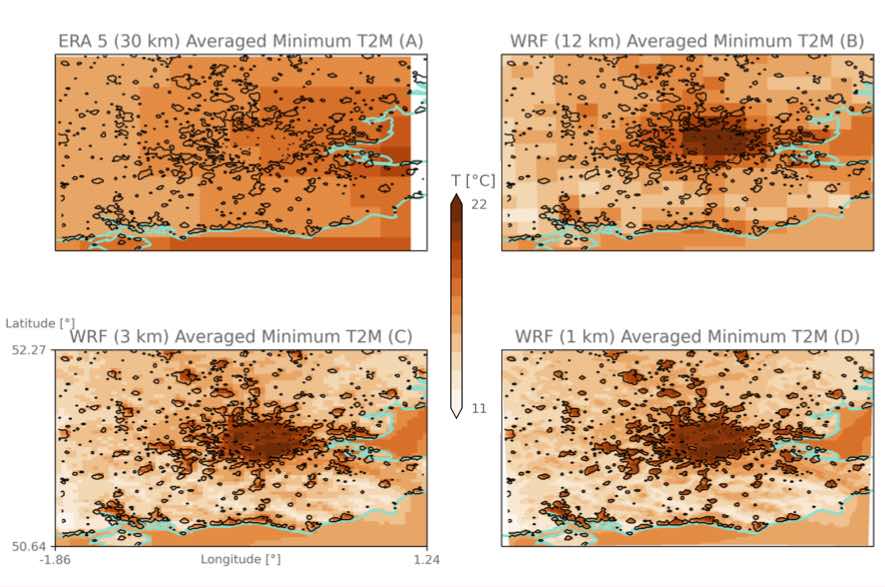
Action
Climate change risk assessment models are an important component of local adaptation strategies. They need to be used by policy makers, strategists, planners and stakeholders to assess potential future impacts of climate change, and to develop actions that will reduce risks. Quantitative estimates of societal risk are essential for long term planning, but local and city scale analysis provides necessary detail to reveal the extent to which a population is exposed or is vulnerable to the effects of heat. This vulnerability depends on multiple factors, including local climate, geography, housing and social and economic factors (Macintyre et al., 2018; Taylor et al., 2018).
Additional city-scale modelling and spatial analysis (based
on high-resolution climate modelling) must add demographic data to 1) identify
vulnerable population groups or geographical areas; 2) investigate the impacts
of potential city-level and neighbourhood-level interventions, and 3) reduce health
inequalities and the potential for unintended consequences from adaptation
measures at local scales. This will enable strategists, planners and others in central
and local government to more effectively prepare appropriate adaptation
responses and focus efforts where they can have the greatest benefit to health
and wellbeing, and to society as a whole.
Acknowledgements
CH is supported by a NERC fellowship (NE/R01440X/1) and acknowledges funding from the Wellcome Trust HEROIC project (216035/Z/19/Z), which funds OB and CS.
References
Basu, R. (2009). High ambient temperature and mortality: A review of epidemiologic studies from 2001 to 2008. Environmental Health: A Global Access Science Source, 8(1). https://doi.org/10.1186/1476-069X-8-40
Field, C. B., Barros, V. R., Stocker, T. F., Qin, D., Dokken, D. J., Ebi, K. L., … Midgley, P. M. (2012). Managing the Risks of Extreme Events and Disasters to Advance Climate Change Adaptation. A Special Report of Working Groups I and II of the Intergovernmental Panel on Climate Change, 1-594. https://doi.org/10.1017/CBO9781139177245
Gasparrini, A., Guo, Y., Sera, F., Vicedo-Cabrera, A. M., Huber, V., Tong, S., … Armstrong, B. (2017). Projections of temperature-related excess mortality under climate change scenarios. The Lancet Planetary Health, 1(9), e360-e367. https://doi.org/10.1016/S2542-5196(17)30156-0
Goodess, C., Berk, S., Ratna, S. B., Brousse, O., Davies, M., Heaviside, C., Moore, C. & Pineo, H. (2021). Climate change projections for sustainable and healthy cities. Buildings and Cities, 2(1), 812-836. https://doi.org/10.5334/bc.111
Hajat, S., Vardoulakis, S., Heaviside, C., & Eggen, B. (2014). Climate change effects on human health: Projections of temperature-related mortality for the UK during the 2020s, 2050s and 2080s. Journal of Epidemiology and Community Health, 68(7), 641-648. https://doi.org/10.1136/jech-2013-202449
Heaviside, C., Vardoulakis, S., & Cai, X.-M. (2016). Attribution of mortality to the urban heat island during heatwaves in the West Midlands, UK. Environmental Health: A Global Access Science Source, 15. https://doi.org/10.1186/s12940-016-0100-9
Macintyre, H. L., & Heaviside, C. (2019). Potential benefits of cool roofs in reducing heat-related mortality during heatwaves in a European city. Environment International, 127, 430-441. https://doi.org/10.1016/J.ENVINT.2019.02.065
Macintyre, H. L., Heaviside, C., Taylor, J., Picetti, R., Symonds, P., Cai, X.-M., & Vardoulakis, S. (2018). Assessing urban population vulnerability and environmental risks across an urban area during heatwaves - Implications for health protection. Science of the Total Environment, 610-611, 678-690. https://doi.org/10.1016/j.scitotenv.2017.08.062
Melorose, J., Perroy, R., & Careas, S. (2015). World population prospects. United Nations, 1(6042), 587-592. https://doi.org/10.1017/CBO9781107415324.004
Taylor, J., Symonds, P., Wilkinson, P., Heaviside, C., Macintyre, H., Davies, M., … Hutchinson, E. (2018). Estimating the influence of housing energy efficiency and overheating adaptations on heat-related mortality in the West Midlands, UK. Atmosphere, 9(5). https://doi.org/10.3390/atmos9050190
Latest Peer-Reviewed Journal Content

Moving homes and energy poverty: residents’ concerns, capabilities and responses
M Jalas, J Rinkinen, S Numminen & E Valkealahti
Reference study for biogenic carbon storage in the residential building stock
O Iliescu, I Talvitie, A Amiri & S Junnila
Building space heating and cooling in NDCs 4.0
T P Lützkendorf
Building component reuse as sociomaterial interaction: lessons from precast concrete
J Uusikartano, L Alkki & V Capitani
Validating national reuse indicators from regional demolition data: a Swedish example
F Ericsson, K Mjörnell & U Janson
Climate change risk and decision-making [editorial]
S Foxell & I Cooper
Technologies of reconstruction [editorial]
P Tombesi
Urban form metrics for building occupancy modelling: applications and impacts
D Reiter, M Jehling & R Hecht
Retrofit realism: affordable low-carbon policies for existing homes
N Eyre & R Khosla
Join Our Community

The most important part of any journal is our people – readers, authors, reviewers, editorial board members and editors. You are cordially invited to join our community by joining our mailing list. We send out occasional emails about the journal – calls for papers, special issues, events and more.
We will not share your email with third parties. Read more
Latest Commentaries
Who is Responsible for Climate Change?
Ian Cooper (Eclipse Research) explores the questions of responsibility raised in the recent Buildings & Cities special issue ‘Climate Change Risk and Decision-Making’. Focusing here on carbon emissions and mitigation, global responses will require grounding in what can work locally. New responsibilities arise for the wide range of built environment decision-makers: clients, professionals and their institutions, central and local governments, product suppliers, financiers, insurers, etc. A framework is needed to manage the complexity of responsibilities especially for variety of actors, the time frames and spatial scales.
Professional Ethics in a Climate Crisis
The climate crisis has progressed into a dangerous phase with tragic consequences often counted in numbers of excess deaths, but also by powerful economic impacts of rising food prices, the increased costs of insurance and lending, costly damage to the built environment. Celia Davies, Director of Impact at the UK’s Town and Country Planning Association (TCPA) and Hugh Ellis, Director of Policy at TCPA, consider the responsibilities of professionals in shaping a built environment which is fit not just for today's climate risks but for the dramatic increase in severe and unpredictable weather which is now locked into our climate systems.