
www.buildingsandcities.org/insights/commentaries/remote-sensing-urban-development.html
Remote Sensing for Urban Development Policies
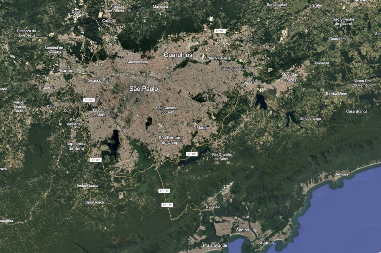
Urban development policy in the Global South is increasingly a question of governing spatial change before it becomes locked in
At the 2026 Sustainable Buildings and Construction Summit Magnus Andersson, David Muthui & Reza Roodaki (Malmö University) argued that remote sensing should be a core evidence infrastructure for sustainable urban governance. Satellite derived and geospatial analysis can observe and monitor urban expansion, densification, land consumption, building form and material demand across jurisdictions and over time. A shift from two-dimensional to three-dimensional sensing and analysis provides new data to inform policies for housing, land-use efficiency, disaster exposure, public space, resource efficiency and resilient construction.
Introduction
Urbanisation in the Global South is reshaping land, infrastructure and material systems at a historically exceptional scale. The United Nations Department of Economic and Social Affairs (UN DESA 2025) estimates that, in 2025, 45% of the world’s 8.2 billion people live in cities, with two thirds of projected population growth to 2050 occurring in cities. Over half of the projected increase in city dwellers will be concentrated in India, Nigeria, Pakistan, the Democratic Republic of Congo, Egypt, Bangladesh and Ethiopia. The same source reports that built up areas expanded almost twice as fast as the global population between 1975 and 2025, with around 60% of land converted to urban use since 1970 having previously been productive farmland (UN DESA 2025).
These trends make urban development policy inseparable from spatial evidence. Conventional data systems often struggle to capture peri urban growth, informal settlement consolidation, incremental building change and post disaster reconstruction. Remote sensing addresses part of this deficit by providing repeated, spatially consistent observations of the built environment. Its policy significance lies not only in mapping where urbanisation occurs, but in showing what form it takes and what it implies for land, infrastructure, climate risk and construction resources.
From urban extent to urban fabric
Angel et al. (2010 and 2016) established a foundational empirical argument: urban land consumption is shaped by both population growth and decline of urban density. In their global sample, urban land cover grew by 3.66% per year between 1990 and 2000, more than twice the 1.66% annual growth of urban population. Their projections showed that global urban land cover would double by 2050 if densities remained constant, triple under a 1% annual density decline and increase more than five-fold under a 2% annual density decline. For Sub-Saharan Africa, the high-density-decline scenario implied more than a twelve-fold increase in urban land cover (Angel et al. 2010 and 2016).
The Atlas of Urban Expansion (Angel et al. 2016) extended this logic into an open comparative resource. It provides maps, satellite images and data for a global sample of 200 cities representing 4,231 cities and metropolitan areas with at least 100,000 people in 2010. Its major contribution was to make the horizontal expansion of cities empirically visible and internationally comparable. Angel (2023) treats expansion and densification as complementary, rather than mutually exclusive, mechanisms for accommodating population growth. Where expansion is denied or left unplanned, cities can experience fragmented settlements, insufficient arterial roads, hazardous occupation, ecological loss, housing exclusion and inadequate public open space. Angel et al. (2021) decompose density into measurable factors such as building height, coverage and crowding. Godoy-Shimizu et al. (2021) connect footprints, floor space, storeys and typologies to energy use. Berghauser Pont et al. (2021) identify gaps between planning motivations and empirical evidence on densification effects. Together, this research supports a balanced proposition: cities need planned expansion where growth is inevitable and evidence based densification where existing fabric can absorb growth without overcrowding, displacement, heat stress or loss of public space.
The current remote sensing agenda builds on this work but shifts the analytical object from urban extent to urban fabric. It is less concerned with whether a city is expanding than with how expansion, infill, vertical growth, building typology and material intensity interact.
This distinction matters for policy. Two neighbourhoods can have similar population densities but radically different urban fabrics: high rise serviced blocks, low rise overcrowded settlements, dispersed peri urban subdivisions or incremental informal consolidation. Treating these as equivalent because their population density is similar risks misallocating infrastructure, underestimating disaster exposure and overlooking embodied carbon consequences. An urban fabric approach therefore translates spatial observation into policy relevant categories.
The remote sensing evidence and build environments
Four data layers are especially important to map a three-dimensional and material aware urban fabric. First, land cover and built up extent identify expansion, impervious surfaces, vegetation loss and the conversion of agricultural land, wetlands and open space. This evidence supports land consumption analysis, green space protection, urban growth management and SDG indicator 11.3.1, which measures the ratio of land consumption rate to population growth rate (UN DESA n.d.; UN-Habitat 2021).
Second, building footprints show the location, size and distribution of structures. When combined with population data, transport networks and service maps, they help identify settlement types, infrastructure deficits, housing stress and exposure to hazards. This is particularly important in contexts where cadastral records are incomplete or informal areas are underrepresented in official statistics (Kuffer et al. 2016).
Third, building height and volume estimates add the vertical dimension of the build environment. Height data distinguish densification from sprawl, improves floor space proxies and provides more realistic estimates of infrastructure demand, reconstruction scale and hazard exposure.
Fourth, material and archetype inference links physical form to construction systems. This remains more uncertain than mapping extent or footprints, but it opens policy relevant analysis of material stocks, embodied carbon, retrofit potential, structural fragility, heat performance and debris generation (Pauliuk & Müller 2014; Rajaratnam et al. 2023).
The value of these four data layers lies in the combination. Land cover maps alone can identify expansion; building footprints reveal settlement grain; height indicates volume and densification; material proxies connect urban form to resource and carbon consequences. Together, these layers allow urbanization and the built environment to be analysed as a coupled system of land, buildings, infrastructure and materials (Andersson et al. 2026).
Remote sensing is most directly relevant to SDG 11, which calls for cities and human settlements to be inclusive, safe, resilient and sustainable (UN DESA n.d.). For target 11.1,1 footprints, density and morphology can support the identification of overcrowded, underserved or informal settlements, although tenure and adequacy require complementary social data. For target 11.3,2 multitemporal built up data directly strengthens land use efficiency monitoring. For target 11.5,3 building exposure, height and material fragility can improve disaster risk assessment and reconstruction prioritisation. For target 11.6,4 land cover, surface imperviousness and material indicators can inform analysis of urban heat, runoff, waste streams and embodied emissions. For target 11.7,5 built up density can be analysed alongside vegetation and open space layers to identify unequal access to green and public space.
However, the relevance extends beyond SDG 11. Material demand estimates support SDG 12 on responsible consumption and production. Spatial analysis of infrastructure gaps supports SDG 9 and exposure analysis contributes to SDG 13 on climate action and disaster resilience. Monitoring the conversion of farmland, wetlands and ecosystems links to SDG 15. Finally, the production and use of interoperable geospatial statistical systems is itself an SDG 17 partnership agenda, requiring cooperation among space agencies, statistical offices, planning authorities, universities, firms and communities (Andersson & Crnojevic 2025).
Governance conditions and conclusion
Remote sensing cannot determine planning legitimacy, housing affordability, tenure security or displacement risk. It can misclassify land cover, under detect small structures, estimate height unevenly and infer information of building materials only indirectly. These limitations make validation using information from stakeholders essential. Satellite derived monitoring should be calibrated with field surveys, engineering knowledge, local planning records, community mapping and official statistics.
The policy value of remote sensing is therefore not the satellite images itself, but the capacity to convert repeated spatial observation into accountable decisions. Compared with the novel data on urban extension presented in the Atlas of Urban Expansion (2016), the frontier is moving from retrospective maps of horizontal growth to operational monitoring of urban fabric. This enables governments to detect expansion, evaluate densification, target infrastructure, reduce hazard exposure, estimate material demand and monitor progress towards the SDGs. The central task is to institutionalise these capabilities in planning and budgeting systems before today’s urban growth becomes tomorrow’s irreversible spatial, fiscal and carbon lock ins.
Notes
1. SDG Target 11.1: By 2030, ensure access for all to adequate, safe and affordable housing and basic services and upgrade slums.
2. SDG Target 11.3: By 2030, enhance inclusive and sustainable urbanization and capacity for participatory, integrated and sustainable human settlement planning and management in all countries.
3. SDG Target 11.5: By 2030, significantly reduce the number of deaths and the number of people affected and substantially decrease the direct economic losses relative to global gross domestic product caused by disasters, including water-related disasters, with a focus on protecting the poor and people in vulnerable situations.
4. SDG Target 11.6: By 2030, reduce the adverse per capita environmental impact of cities, including by paying special attention to air quality and municipal and other waste management.
5. SDG Target 11.7: By 2030, provide universal access to safe, inclusive and accessible, green and public spaces, in particular for women and children, older persons and persons with disabilities.
References
Andersson, M., & Crnojevic, V. (2025). Space applications and global sustainable development. Science-Policy Brief for the UN Multistakeholder Forum on Science, Technology and Innovation for the SDGs.
Andersson, M., Muthui, D., & Roodaki, R. (2026). From urban extent to urban fabric: Remote sensing evidence for SDG 11. Science-Policy Brief for the Multi-stakeholder Forum on Science, Technology and Innovation for the SDGs.
Angel, S. (2023). Urban expansion: Theory, evidence and practice. Buildings & Cities, 4(1), 124-138. https://doi.org/10.5334/bc.348
Angel, S., Parent, J., Civco, D., Blei, A., & Potere, D. (2010). Projecting urban land cover in all countries, 2000–2050. In: A Planet of Cities: Urban land cover estimates and projections for all countries, 2000–2050. Lincoln Institute of Land Policy.
Angel, S., Blei, A., Parent, J., Lamson-Hall, P., Galarza Sánchez, N., Civco, D. L., Lei, R. Q., & Thom, K. (2016). Atlas of urban expansion—2016 edition: Volume 1: Areas and densities. NYU Urban Expansion Program at New York University, UN-Habitat, and Lincoln Institute of Land Policy. http://www.atlasofurbanexpansion.org/
Angel, S., Lamson-Hall, P., & Gonzalez Blanco, Z. (2021). Anatomy of density: Measurable factors that constitute urban density. Buildings & Cities, 2(1), 264-282. https://doi.org/10.5334/bc.91
Berghauser Pont, M., Haupt, P., Berg, P., Alstade, V., & Heyman, A. (2021). Systematic review and comparison of densification effects and planning motivations. Buildings & Cities, 2(1), 378-401. https://doi.org/10.5334/bc.125
Godoy-Shimizu, D., Steadman, P., & Evans, S. (2021). Density and morphology: From the building scale to the city scale. Buildings & Cities, 2(1), 92-113. https://doi.org/10.5334/bc.83
Kuffer, M., Pfeffer, K., & Sliuzas, R. (2016). Slums from space: 15 years of slum mapping using remote sensing. Remote Sensing, 8(6), 455. https://doi.org/10.3390/rs8060455
Pauliuk, S., & Müller, D. B. (2014). The role of in-use stocks in the social metabolism and in climate change mitigation. Global Environmental Change, 24, 132–142. https://doi.org/10.1016/j.gloenvcha.2013.11.006
Rajaratnam, D., Stewart, R. A., Liu, T., & Vieira, A. S. (2023). Building stock mining for a circular economy: A systematic review of applications of GIS and remote sensing. Resources, Conservation & Recycling Advances, 18, 200144.
United Nations Department of Economic and Social Affairs. (n.d.). Goal 11: Make cities and human settlements inclusive, safe, resilient and sustainable. https://sdgs.un.org/goals/goal11
United Nations Department of Economic and Social Affairs. (2025). World Urbanization Prospects 2025: Key messages. https://population.un.org/wup/
UN-Habitat. (2021). Indicator 11.3.1 training module: Land use efficiency. UN-Habitat.

Latest Peer-Reviewed Journal Content

Building space heating and cooling in NDCs 4.0
T P Lützkendorf
Building component reuse as sociomaterial interaction: lessons from precast concrete
J Uusikartano, L Alkki & V Capitani
Validating national reuse indicators from regional demolition data: a Swedish example
F Ericsson, K Mjörnell & U Janson
Climate change risk and decision-making [editorial]
S Foxell & I Cooper
Technologies of reconstruction [editorial]
P Tombesi
Urban form metrics for building occupancy modelling: applications and impacts
D Reiter, M Jehling & R Hecht
Retrofit realism: affordable low-carbon policies for existing homes
N Eyre & R Khosla
Inside offsite: everyday dwelling in factory-built apartments
L Dorignon & R Horne
MMC for housing: sectoral perception on governance challenges
J Morgan, C Goodier, R Schmidt-III & K Ayinla
Reorganising specification practice for component reuse: an exploratory study
S Gao, K Jones, J Xu & J Glass
Kitchen retrofits to support food practices and wellbeing
F J Andrews, A Sal Moslehian, E Warner & R Tucker
From strategy to delivery: a comparative analysis of MMC roadmaps
G Goldman, D Sorokine, F Suerich-Gulick, C Carbone & M Jemtrud
Thermal comfort, ventilation and mosquito-borne disease risk in Zanzibar hospitals
O Sloan Wood, J B Knudsen, K L Schiøler, E Lupenza, M Msellem & F Saleh
Reusing precast concrete elements in construction: assessing the economic conditions
O Vigren, H Westerlind & T Malmqvist
Institutional readiness for industrialised social housing in Vietnam
T Q Nguyen, B N Nguyen, T H Q To & Z Aziz
Prefabrication for housing retrofit: governance, innovation and resident experience
E Pikas, K Kuusk, P Pihelo, R Liias, J Pukk & T Kalamees
Reframing heat pump transitions: a care perspective
J van der Haer, R Schelwald & F de Haan
Urban informal settlements in Africa: transforming adaptation governance
K Buyana & H Sseviiri
Reusing concrete products in indoor environments: chemical hazard assessment
K Tähtinen, A Helin, E Parshintsev & H Hovi
Negotiating net-zero carbon: an ANT analysis of two buildings
L Schweber & M Green
Design for disassembly: a review of public policy proposals
O Vorobjev, U Uotila, T Joensuu & A Saari
Retrofitting Norwegian residential buildings: an archetype-based dynamic stock model
L S A Rousseau, S Amini, S Akin & E G Hertwich
Decolonising time: vernacular villages and the politics of heritage temporality
R Al-Rabady
Commutes to alternative workplaces: GHG emissions and physical activity
J Taylor, L Thoen, A Espinosa Mireles De Villafranca, P Anashin, J Vanhatalo, D Milián
Bernal & I Okkonen
Nine ‘myths’ about the building stock of Great Britain
S Evans, P Steadman, A Neto-Bradley, D Humphrey, R Liddiard,H Shamsi, J Palmer & G Simons
Join Our Community

The most important part of any journal is our people – readers, authors, reviewers, editorial board members and editors. You are cordially invited to join our community by joining our mailing list. We send out occasional emails about the journal – calls for papers, special issues, events and more.
We will not share your email with third parties. Read more
Latest Commentaries
Who is Responsible for Climate Change?
Ian Cooper (Eclipse Research) explores the questions of responsibility raised in the recent Buildings & Cities special issue ‘Climate Change Risk and Decision-Making’. Focusing here on carbon emissions and mitigation, global responses will require grounding in what can work locally. New responsibilities arise for the wide range of built environment decision-makers: clients, professionals and their institutions, central and local governments, product suppliers, financiers, insurers, etc. A framework is needed to manage the complexity of responsibilities especially for variety of actors, the time frames and spatial scales.
Professional Ethics in a Climate Crisis
The climate crisis has progressed into a dangerous phase with tragic consequences often counted in numbers of excess deaths, but also by powerful economic impacts of rising food prices, the increased costs of insurance and lending, costly damage to the built environment. Celia Davies, Director of Impact at the UK’s Town and Country Planning Association (TCPA) and Hugh Ellis, Director of Policy at TCPA, consider the responsibilities of professionals in shaping a built environment which is fit not just for today's climate risks but for the dramatic increase in severe and unpredictable weather which is now locked into our climate systems.